O'Donnell Link
![]()
![]()
Introduction
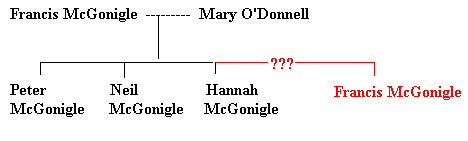
This is one of the ‘old’ families in County Donegal. How are we related to this family? From Frank McGonigle’s death certificate we learn that his father’s name may have been Peter McGonigle. No mother’s name is given. His obituary mentions a brother living in Rock Island, Illinois. We strongly suspect this ‘missing brother’ is Neil McGonigle, who lived in nearby Mercer County. Neil’s descendents lived in Rock Island County, Illinois. From Neil McGonigle’s marriage license we learn his parents were Francis McGonigle and Mary O’Donnell. This family is from Killybegs, County Donegal.
There is a Peter McGonigle in the family chart below. He died twenty years before Francis McGonigle died. Neil died a year after Francis. We have written about Peter McGonigle and his family before. Peter married Ann Murrin in Killybegs. Our ancestor, Francis McGonigle, married Kate Murrin in Belvidere, Illinois. In fact, all the McGonigles listed below lived in Killybegs, County Donegal.
McGonigle Connection
The following chart is what I believe our family tree looks like. Unfortunately, I cannot conclusively prove it yet. That is why Francis’s name and link is highlighted in red. At the very least they are all related. By 1840 there were only 3 McGonigle leaseholders listed in Upper Killybegs Civil Parish. This included Francis McGonigle, Farigle McGonigle and Daniel McGonigle, and they all lived in close proximity to each other.
First you will read a short history of the O’Donnell family in County Donegal. Next, you will see where this family lived in Upper Killybegs Civil Parish, County Donegal, Ireland.
History of the O’Donnell Family in County Donegal
Niall of the Nine Hostages was this family’s early ancestor. Niall raided Britain and France towards the end of the 4th century AD. The O’Donnell family of Tirconnell descends from Niall’s son, Conall Gulban. The McGonigle family also descends from Conall Gulban. Their Gaelic name, Domhnaill, means ‘world mighty’ and is an ancient and popular Irish personal name. The land known as Tirconnell in time became known as Donegal. The O’Donnell family was a powerful family in this part of Ulster and kept their power for many generations. Their chiefs were inaugurated at Kilmacrenan, which is north of Letterkenny in County Donegal. Like many of the ruling families of their time, they were swept up in tribal conflict. Chiefly, they kept busy attacking their own kinsmen, the O’Neills.
The O’Donnell family were erenaghs of Letter and Lisfannon in the parish of Fahan in Inishowen. Erenaghs were in charge of church land and the title is hereditary. The McGonigle family were erenaghs of Killybegs. With a total of nearly 13,000 the O’Donnells are among the fifty most common names in Ireland.
Heraldry
At the top you saw the O’Donnell coat of arms. From old records we know Conall Gulban was converted to Christianity by St. Patrick. To reward Conall for his religious fervor, Patrick made the sign of the cross on Conall’s shield. This symbol was borne by Conall’s descendents, the Lords of Tirconnell, long before any formal system of heraldry existed. There is also another coat of arms associated with this family, and it is similar to the Ui Neill coat of arms.
Family Motto
In hoc signo vinces. (Under this sign we are victorious).
Name Variations: (English) O’Donnell, O’Donell, O’Donel, (Gaelic) Ó Dómhnaill, Ó Dónaill
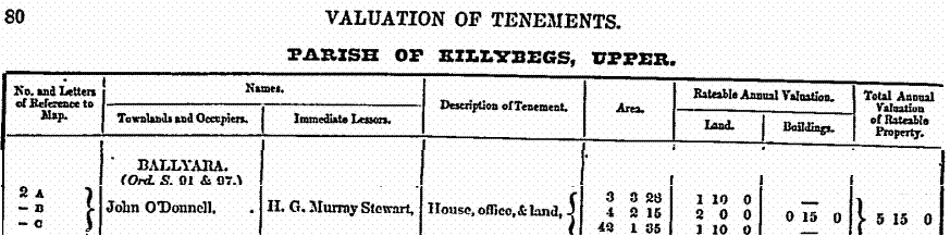
Ballyara Townland
Ballyara is located midway between Killybegs and neighboring Kilcar Civil Parish. The 1858 Griffith Valuation shows one John O’Donnell leasing land in this townland. It appears he leased in excess of 40 acres. Although this is a lot of land, you must remember that much of this land was unsuitable for farming. The accompanying map shows his leased land.
|
Townland |
AKA |
Acres |
County |
Barony |
Civil Parish |
PLU |
Province |
|
Ballyara |
|
900 |
Donegal |
Banagh |
Killybegs Upper |
Glenties |
Ulster |

Corporation Townland
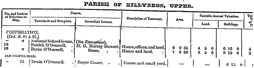
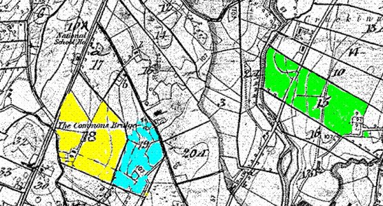
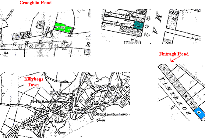
Corporation Townland is north of and adjacent to Killybegs Townland. Killybegs townland includes Killybegs Town. In 1858 the following O’Donnell names were found living in this Townland: Patrick O’Donnell, Bryan O’Donnell and Denis O’Donnell. Patrick and Bryan lived side by side as indicated by the map below.
|
Townland |
AKA |
Acres |
County |
Barony |
Civil Parish |
PLU |
Province |
|
Corporation |
|
358 |
Donegal |
Banagh |
Killybegs Upper |
Glenties |
Ulster |
Cullion Townland
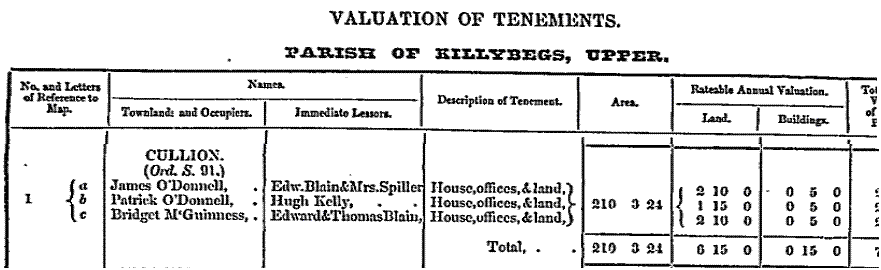
This townland is located north of Killybegs town on the way to Ardara Civil Parish. The following O’Donnell names were found in the 1858 Griffith Valuation Survey: James O’Donnell and Patrick O’Donnell. In fact, the whole townland acreage was co-leased by the O’Donnells and Bridget McGuinness. Two lakes bordered this townland on the west and north.
|
Townland |
AKA |
Acres |
County |
Barony |
Civil Parish |
PLU |
Province |
|
Cullion |
|
210 |
Donegal |
Banagh |
Killybegs Upper |
Glenties |
Ulster |
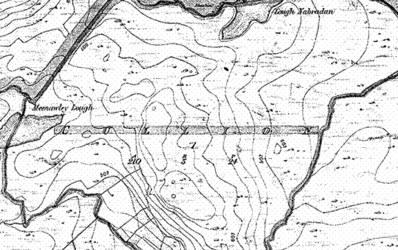
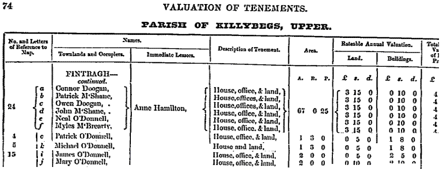
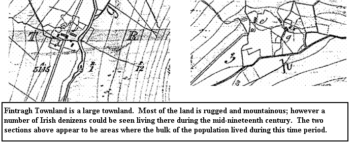
Fintragh Townland
This large townland is one of the westernmost and most mountainous areas in this part of Ireland. The following 1858 Griffith Record is a good example of families sharing responsibilities. It appears six families co-leased land in this townland. The following O’Donnell names are found listed in this record: Neal O’Donnell, Patrick O’Donnell, Michael O’Donnell, James O’Donnell and Mary O’Donnell.
|
Townland |
AKA |
Acres |
County |
Barony |
Civil Parish |
PLU |
Province |
|
Fintragh |
|
3,145 |
Donegal |
Banagh |
Killybegs Upper |
Glenties |
Ulster |
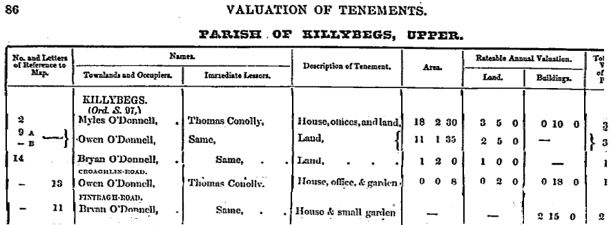
Killybegs Town and Killybegs Townland
The following O’Donnell names were found listed in the 1858 Griffith Valuation Survey: Myles O’Donnell, Owen O’Donnell, Bryan O’Donnell, and what appears to be another Bryan O’Donnell. The maps below show where these O’Donnells lived.
|
Townland |
AKA |
Acres |
County |
Barony |
Civil Parish |
PLU |
Province |
|
KILLYBEGS T. |
|
xx |
Donegal |
Banagh |
Killybegs Upper |
Glenties |
Ulster |
|
Killybegs |
|
325 |
Donegal |
Banagh |
Killybegs Upper |
Glenties |
Ulster |
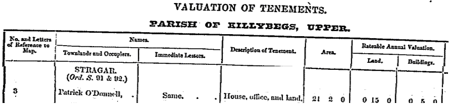
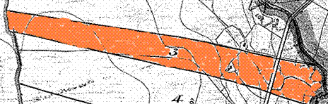
Stragar Townland
Stragar Townland is located north of Killybegs. In 1858 we find one Patrick O’Donnell leasing land, house and office in this Townland. The map below shows the land leased by Patrick O’Donnell.
|
Townland |
AKA |
Acres |
County |
Barony |
Civil Parish |
PLU |
Province |
|
Stragar |
|
908 |
Donegal |
Banagh |
Killybegs Upper |
Glenties |
Ulster |
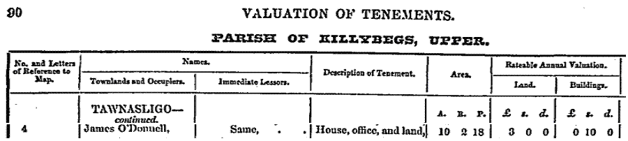
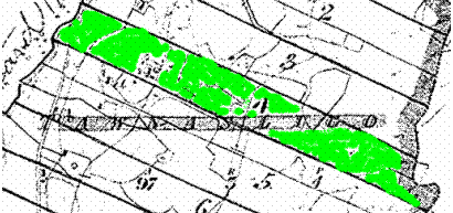
Tawnasligo Townland
Tawnasligo Townland is located directly east of Killybegs on the other side of Killybegs harbor. In 1858 James O’Donnell lived in this Townland.
|
Townland |
AKA |
Acres |
County |
Barony |
Civil Parish |
PLU |
Province |
|
Tawnasligo |
|
97 |
Donegal |
Banagh |
Killybegs Upper |
Glenties |
Ulster |