

McCarval Family
McCarval Family
Smith Family Genealogy
County Monaghan, Ireland
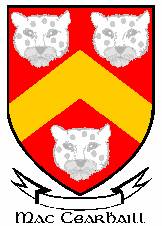
Introduction
The McCarval Family intersects with our family through marriage. McCarval is also seen spelled as McCarville. We know there was a family relationship with a McCarville family in Sauk County, Wisconsin. In fact, a McCarville also attended Irish John Smith’s funeral in 1928. The following chart shows how this family is aligned with our own.

It is also possible the McCarval (McCarville) family is related in some other way to our family. This write-up is the latest installment of the Smith family genealogy.
Aghabog Civil Parish
We found this tidbit contained in the Parliamentary Gazetteer of Ireland: Adapted to the New Poor-Law, which was published in 1846.
AGHABOG, a parish on the eastern border of the barony of Dartry, 5 miles east-south-east of Clones, co. Monaghan, Ulster. Length, 4 miles; breadth, 2; area 11,543 acres. Pop., in 1831, 7,442; in 1841, 7,530. Houses 1,319. Leysborough is the only demesne. Large patches of bog occur on the north; and extensive tracts of bog expand on the east and west. The aggregate soil is tolerably good for oats. A lake near Leysborough is the largest in the barony; and there are four other lakes. The road from Monaghan to Cootehill passes through the interior – This parish is a rectory, and a separate benefice in the dio. Of Clogher. Gross income 402 pounds 12 shillings; nett, 357 pounds 17 shillings. Patron, the diocesan. A Presbyterian meeting-house, formerly Secessional, but now belonging to the General Assembly, is attended by 325; and a Roman Catholic chapel by 850. In 1834, there were 1,567 Churchmen, 1,753 Presbyterians, 1 other Protestant dissenter, and 4,121 Roman Catholics. In the same year, there were four schools of the London Hibernian Society, two National schools, and two hedge-schools, with aggregately 458 boys and 292 girls on their books.
Dartry Barony
Parishes or parts of parishes were consolidated into baronies. Aghabog Civil Parish was part of Dartree Barony, sometime known as Dartree Barony. The following information regarding this barony was found in The Radical Cure for Ireland, by Arthur Chichester in 1890.
119. 7. Dartrey.—The parishes of Aghabog, Ematris, and Currin (Fermanagh and Monaghan); the townlands of Closagh Beg and Clossagh More, in the parish of Aghnamullan; the parish of Killeevan, except the thirty-nine townlands included in the new barony of Clankelly. Population, 11,871; Protestants, 5435.
County Monaghan Map
For reference we include a map showing the Civil Parishes for County Monaghan as they existed in the mid-nineteenth century. Civil Parishes are old administrative units, perhaps dating as far back as medieval times.

Civil Parishes can be seen in the map above. They include: (1) Aghabog; (2) Aghnamullen; (3) Ballybay; (4) Clones; (5) Clontibret; (6) Currin; (7) Donagh; (8) Donaghmoyne; (9) Drummully; (10) Drumsnat; (11) Ematris; (12) Errigal Trough; (13) Inishkeen; (14) Killanny; (15) Killeevan; (16) Kilmore; (17) Magheracloone; (18) Magheross; (19) Monaghan; (20) Muckno; (21) Tedavnet; (22) Tehallan; and (23) Tullycorbet.
Valuations of Land Leased in County Monaghan
The valuations generally were based on valuation tables found in the book below which was printed in 1771. The book’s title is ‘Tables for the Easy Valuing of Estates from One Shilling to Five Pounds Per Acre: Also the Parts of an Acre from 3 Roods to one Perch”.

Genagh Townland
Aghabog Civil Parish
This entry shows the only McCarval surname registered in Aghabog Civil Parish. Genagh Townland is composed of 196 acres and is located in County Monaghan, Dartree barony, Clones PLU in the Province of Ulster.

Genagh Townland Map
Bernard McCarval leased land in section 8 as seen in this map of Genagh Townland.

Killycoonagh Townland
Killeevan Civil Parish
Killycoonagh Townland is composed of 231 acres and is located in County Monaghan, Dartree Barony, Killeevan Civil Parish, Clones PLU in the Province of Ulster. In the mid-nineteenth century we find Terence McCarval listed in the Valuation List.
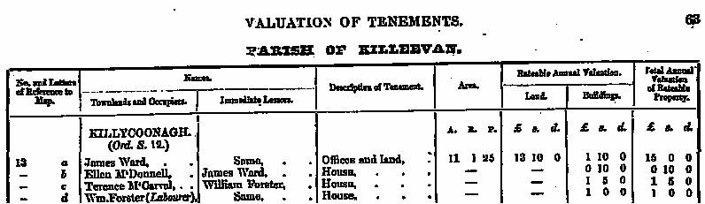
Map of Killycoonagh
It appears Terence McCarval co-leased land with James Ward, Ellen McDonnell and William Forster (Labourer). Forster was an elite name in County Monaghan and ‘labourer’ signifies the status for this ‘William Forster. A Forster family owned an estate in County Monaghan.

Killyfuddy Townland
Killeevan Civil Parish
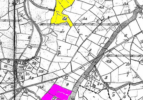
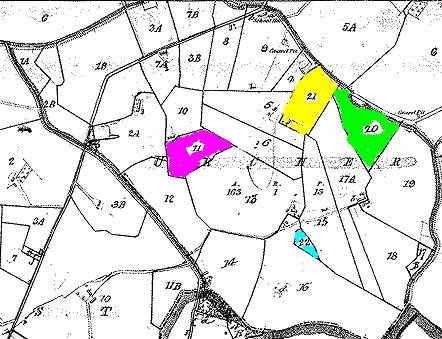
Killyfuddy is a townland composed of 207 acres, County Monaghan, Dartree Barony, Killeevan Civil Parish, Clones PLU in the Province of Ulster. In this townland we find land leased to Felix McCarval and Francis McCarval.
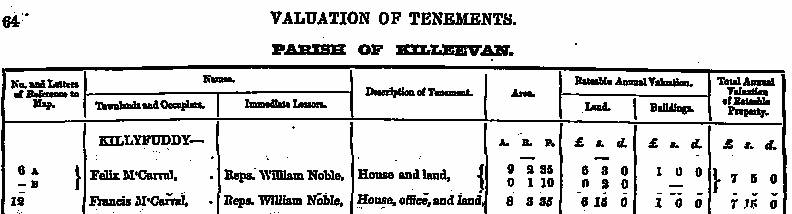
Map of Killyfuddy
Felix McCarval leased land that has been highlighted in yellow. Francis McCarval leased land that has been highlighted in purple.
Aghnaglough Townland
Kilmore Civil ParishTownland AKA Acres County Barony Civil Parish PLU
Aghnaglough Townland is composed of 221 acres in County Monaghan, Monaghan Barony, Kilmore Civil Parish, Monaghan PLU in the Province of Ulster. Three McCarval surnames are found listed in this Valuation of Tenements. They were Felix McCarval, Catherine McCarval, and Patrick McCarval
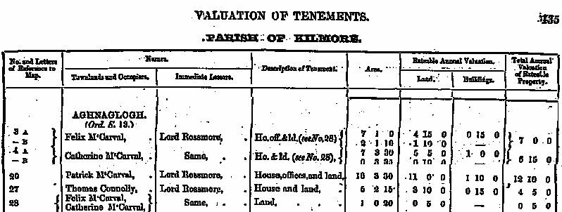
Map of Aghnaglogh
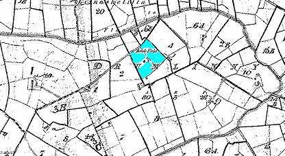
The following shows land leased to various McCarval families during the mid-nineteenth century. Generally speaking, one could assume that surnames found in close proximity to each other might indicate a close relationship. Section 28 is the land parcel highlighted in blue.

Drumlinny Townland
Kilmore Civil Parish
Drumlinny Townland is composed of 80 acres and is located in County Monaghan, Monaghan Barony, Kilmore Civil Parish, Monaghan PLU in the Province of Ulster. One McCarval, Patrick, leased land in this townland during the middle part of the nineteenth century.
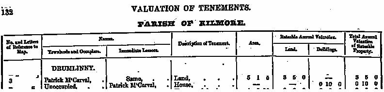
Map of Drumlinny
The map below shows land leased by Patrick McCarval in Drumlinny Townland
Loyst Townland
Kilmore Civil Parish
Loyst Townland is composed of 224 acres and is located in County Monaghan, Monaghan Barony, Kilmore Civil Parish, Monaghan PLU in the Province of Ulster. James McCarval leased land in this townland during the middle part of the nineteenth century.
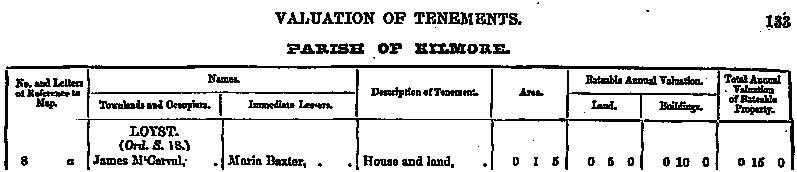
Map of Loyst
From this map we are unable to determine exactly where James McCarval leased land.
Urcher Townland
Kilmore Civil Parish
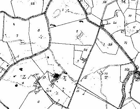
Urcher Townland contains 163 acres and is found in County Monaghan, Monaghan Barony, Kilmore Civil Parish, Monaghan PLU in the Province of Ulster. This townland has been of interest to us for quite some time. It is perhaps only 1 or 2 miles from Irish John’s home area of Rossnaglogh East. You may recall that Irish John’s mother was born Catharine Greenan. This townland contains many Greenan surnames. Catharine’s brother was named Terence. This is the only place in County Monaghan where we have see this name listed in the Griffith Valuation Survey. Earlier Tithe records for 1832 showed a Terence Greenan living near Irish John’s home in Rossnaglogh East. Also, you will see a Catharine Smyth listed as leaseholder during the mid-nineteenth century. Mary McCarval and Bridget McCarval leased land next to this Catharine Smyth.

Map of Urcher
Please refer to the Valuation List above to see who leased land in this particular townland.
Other McCarval and Variations living in County Monaghan
|
Last Name |
First Name |
Parish |
Townland |
|
McCarvill |
Patrick |
Aghabog |
Calliagh |
|
McCarville |
Thomas |
Aghabog |
Corramegan |
|
McCarvill |
Peter |
Aghabog |
Drumlinny |
|
McCarvill |
Patrick |
Aghabog |
Garrant |
|
McCarvill |
Michael |
Aghabog |
Liscumasky |
|
McCarvill |
James |
Aghabog |
Liscumasky |
|
McCarvill |
James |
Aghabog |
Tattintlieve |
|
McCarvill |
Patrick |
Aghabog |
Tattintlieve |
|
McCarvill |
Myles |
Aghabog |
Tattintlieve |
|
McCarvill |
John |
Aghabog |
Tattintlieve |
|
McCarvill |
Terence |
Clones |
Killina |
|
McCarvel |
Thomas |
Ematris |
Coolkill, East |
|
McCarvill |
Terence |
Killeevan |
Lecklevera |
|
McCarvill |
Thomas |
Killeevan |
Lecklevera |
|
McCarvill |
Patrick |
Killeevan |
Lecklevera |
|
McCarvill |
Henry |
Monaghan |
Mullaghmonaghan |